성경에 관련된 지도: 두 판 사이의 차이
Good4Joy
편집 요약 없음 |
편집 요약 없음 |
||
| 4번째 줄: | 4번째 줄: | ||
파일:Middle East Shem-Ham.jpg|노아의 후손 셈, 함의 땅 | 파일:Middle East Shem-Ham.jpg|노아의 후손 셈, 함의 땅 | ||
파일:Egypt 1450 BC.png|BC 1450경 이집트와 중동지역 | 파일:Egypt 1450 BC.png|BC 1450경 이집트와 중동지역 | ||
파일:Kingdom of Israel.png|사울과 다윗 왕 통일 왕국 당시 이스라엘 (BC 11세기, 빨간색은 속국) | |||
파일:12 Tribes of Israel Map.svg.png|12 지파의 땅, BC 1200-1050 | 파일:12 Tribes of Israel Map.svg.png|12 지파의 땅, BC 1200-1050 | ||
Image:Kingdoms of Israel and Judah map 830.svg.png|이스라엘과 주변 국가 - BC 9 세기 | Image:Kingdoms of Israel and Judah map 830.svg.png|이스라엘과 주변 국가 - BC 9 세기 | ||
| 10번째 줄: | 11번째 줄: | ||
파일:First century Iudaea province.gif|예수님 사역 당시 유대와 갈릴리 지역 | 파일:First century Iudaea province.gif|예수님 사역 당시 유대와 갈릴리 지역 | ||
파일:Palestine in the time of Jesus.jpg|예수님 당시 팔레스타인 | 파일:Palestine in the time of Jesus.jpg|예수님 당시 팔레스타인 | ||
파일:Broad overview of geography relevant to paul of tarsus.png|바울 선교 관련 지역 | |||
파일:Seven churches of asia.png|계시록 일곱 교회와 밧모섬의 위치 | |||
파일:Islam percent population in each nation.png|2014년 인구별로 보는 이슬람 | |||
</gallery> | |||
<!-- | |||
파일:Paul map korean thessalonians.png|데살로니가 위치 | 파일:Paul map korean thessalonians.png|데살로니가 위치 | ||
파일:Paul-map-korean-corinth.png|고린도 위치 | 파일:Paul-map-korean-corinth.png|고린도 위치 | ||
파일:Paul map korean ephesus.png|에베소 위치 | 파일:Paul map korean ephesus.png|에베소 위치 | ||
파일:Paul map colossae.png|골로세 위치 | 파일:Paul map colossae.png|골로세 위치 | ||
파일:Paul map galatia.png|갈라디아 위치 | 파일:Paul map galatia.png|갈라디아 위치 | ||
파일:Paul map philippi.png|빌립보 위치 | 파일:Paul map philippi.png|빌립보 위치 | ||
--> | |||
[[분류:성경공부]] | [[분류:성경공부]] | ||
2020년 3월 6일 (금) 03:24 판
성경관련 지도입니다.
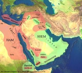
노아의 후손 셈, 함의 땅
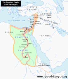
BC 1450경 이집트와 중동지역
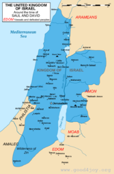
사울과 다윗 왕 통일 왕국 당시 이스라엘 (BC 11세기, 빨간색은 속국)

12 지파의 땅, BC 1200-1050

이스라엘과 주변 국가 - BC 9 세기
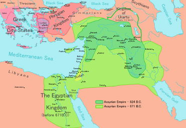
671 BC 앗수루 왕국 (Assyrian empire)

바벨론 포로 경로 - BC 6 세기
- First century Iudaea province.gif
예수님 사역 당시 유대와 갈릴리 지역
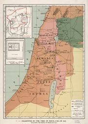
예수님 당시 팔레스타인

바울 선교 관련 지역
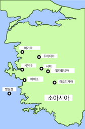
계시록 일곱 교회와 밧모섬의 위치

2014년 인구별로 보는 이슬람


